Throughout my educational career, I have always enjoyed writing. I love to write and create a story. However, this does not mean that I do not struggle with it. In the past, I have struggled with trying to create a perfect paper. Since I began this class though, I have felt as though my work does not have to be perfect. Instead, it needs to convey the message I want to get across. When I came to my professor, Dr. Frances, for help, she did not criticize my work like past professors and high school teachers have. Instead she guided me though my work with constructive recommendations which I greatly appreciated. My relationship with writing has changed as I am not trying to be a perfect writer. Instead, I now work to convey a message.
My writing style is not that different when composing visual texts. I still analyze and explain the claims I make to get my idea across to the reader. What has changed though is the outline of the writing. I don’t write a closed thesis like I typically would when writing a paper. Instead, I leave it open, with room to expand and include new, relevant ideas to get my audience thinking and engaged.
My reading style when reading visual texts is different than reading word text because I have to analyze it differently. Instead explicitly reading words, I have to read lines, boundaries, and dates. To see the different representations of power, I must also look at more than one visual representation. The person who created it has the power to dictate what their audience sees, and I have to take that into consideration. I also analyze visual text differently because of the fact there are no words. I have to look at all aspects of the visual data to interpret it. When analyzing written words, I comprehend the information word by word. That is not the case in visual data.
Overall, this class has taught me to look at visual data more critically than what I have in the past. I need to look at who created it, what their agenda may be, and the cause and effect the visual data may be representing. All in all, this class and what I have studied has made me more aware of the data all around me.
Organization is a normal aspect of everyday life. We may organize our day, our week, our work schedule, our eating plans – we can organize so much in our lives, the list is endless. Have you ever stopped to think about how you organize all this information, and why you do it?
One way to organize information is in a taxonomy. A taxonomy takes advantage of the hierarchical system of organization in which there are main points or headings and subheadings under those. This system is easy to follow and presents a clear and concise path to organized data.
Another way to organize information is in a folksonomy. This method is much more complicated as it is comprised of multiple tags that all can lead back to one idea. This is how much of the online world is connected. There are multiple tags on one post that connect it to multiple ideas that could be searched. In folksonomy, there is an abundance of pathways that connect similar ideas. It is not a simple hierarchical system like taxonomy.
In my English 212 class, we were instructed to create a taxonomy and folksonomy of the topics we have covered thus far in the semester.
For my taxonomy, I organized it by major concepts we have covered in mapping, lines, and the main ideas within each of those topics. Below is the taxonomy I created:
Major Concepts
Mapping and Social Equality
Maps: Politics and Art
Maps: Spatial Experience
Lines: Timelines
Lines: Taxonomies
Important Ideas in Mapping
Power
Knowledge
Political Propaganda
Military
Contested Spaces
Gerrymandering
Contested Spaces
Psychogeography
Mental Mapping
Important Ideas in Lines
Taxonomy
Folksonomy
Timelines
Networking
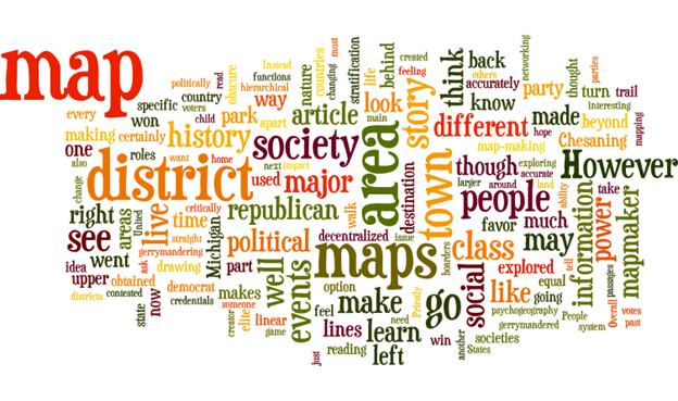
After creating this taxonomy, I then took all of my past blog posts and Canvas discussions to create a word cloud which is an example of a folksonomy. This information is all a “tag” to the information in my taxonomy. It is all related to it in some way. Below is the world cloud/folksonomy:
As you can see, my taxonomy and folksonomy are drastically different. Though they are related to similar topics, the information you retain from them is different. The first thing I noticed is the folksonomy overly highlights the mapping concept. The word map, maps, district, society, and area stand out the most. These ideas are all subsets of the concept of mapping. Moreover, if you look deeper into “the cloud” you can see the words information, power, history, credentials, and story. These words indicate that there is deeper information that relates to each of the main topics mentioned in the taxonomy. Specifically, they elaborate on the simple concepts in lines and mapping. Overall, the word cloud digs deeper into the information behind mapping and lines while the taxonomy looks at the surface of those same ideas.
I personally find the taxonomy easier to understand, especially if I want to retain information in a quick and easy way. However, I find the abstractness of the folksonomy more intriguing. It’s unique, fun, and a great way to look at deeper meanings behind surface-like concepts.
Taxonomies and folksonomies are certainly unique in their uses. Think about it, would you want your teacher to write out a study guide as a taxonomy or folksonomy? The taxonomy would clearly make more sense as it is easily understandable. However, you could use a folksonomy to build off the concepts in the taxonomy to help you better understand the material. I did the exact same thing in the creation of my taxonomy and folksonomy. The word cloud simply built off the ideas in the taxonomy in an abstract way!
I want to encourage each of you to try to create a taxonomy and folksonomy of something you organize in your everyday life! Who knows, maybe you’ll gain a deeper understanding of what you’re organizing and be able to apply it differently.
In our day to day life, we typically go where we need to and back home. We go to the destination we have in mind – work, the grocery store, daycare, shopping – and do not do much exploring beyond that.
This leads me to the question of how well do you know the town you live in? Could you describe to someone how to get anywhere in your town or only to the places you go? The knowledge of where we live and travel is limited to where we go. Psychogeography, however, is a science that teaches you to explore beyond your destinations and learn more about an area. In simple terms, psychogeography is exploring without directions or a destination to discover more about an area. It explores the geographical effects of an area on one’s emotions as well. It allows one to dig deeper into a location to learn more about it than a simple destination.
To explore this science myself, I went on a psychogeography walk and explored the town of Chesaning. I have been to Chesaning numerous times, but I always have a destination. I definitely could not describe where everything in the town is. So, to learn more, I explored with no route in mind. I brought my lovely mom, Denice, with me and we explored together. We started our journey across from the park, and when we approached an area where we had to make a decision to turn, we played rock-paper-scissors. If she won, we went left. If I won, we went right. And if we both gave the same symbol, we went straight. We had some interesting experiences on our excursion, and I certainly explored areas I hadn’t before.
We started at the top of the map, across from the park. We ended at the school after half an hour and exploring.
The journey started off well. Every time we came to an intersection we had the option of going left or right. Our rock-paper-scissor game even lead us across the beautiful bridge onto the other side of town. However, once we crossed the bridge, an issue arose. The only option to stay on the trail was to go right. However, my mom won the game of rock-paper-scissors, and we had to go left. We are adventurous people so we thought, why not? After all, it did look like a nature trail. We did a little off path exploring down the river and saw lots of animal tracks, nature, and amazing views. I experienced a peaceful yet exciting feeling I had not had in that town before as I was entering a new and exciting area.
This is the bridge my mom and I walked across to get to the other side of the river.
This is the view from the nature trail our game took us to.
This is the nature trail we went down.
Once we reached the end of the trail though, we ran into another issue. There was a dead end! Our only option was to turn around and go back, which we did until we reached our next intersection. This time, our options were to turn left into the suburbs, or right, into the park. After a game of rock paper scissors, I won and to the park we went. At this point, I was experiencing major feelings of nostalgia as this was the park I went to as a young child. I had not been back there in a long time, and I couldn’t help but remember all the amazing memories I had made there.
Beyond these emotions though, we yet again had another issue. There was no right option! It was we must turn left or turn around. Luckily, my mom won and we cut left, through the park, up to the main street.
This is the park that I grew up playing at as a young child.
This is the area of the park that we cut through to get to the main road.
Once we got to the main street, it was pretty smooth sailing and each of our games of rock paper scissors took us straight, and we ended up at the local elementary school. This part of the walk felt normal and similar to how I typically feel when going to Chesaning.
My experience with psychogeography allowed me to go beyond where I have explored before, and it brought feelings I have not had since I was a child. Going on an adventure with no destination can take you places where peace and nature are present, like the nature trail we happened to stumble upon. More than that though, it can take you back to those childlike days, like when I ended up in the park.
After this walk, my perspective of Chesaning has changed. I now see it as an area that is both a city and a rural area. Before, I mainly saw this town as, well, a town! I now know that it is much more than that. It has nature, trails, and animals. An area for both you and creatures to dwell in! More than that though, it is not a town full of hustle and bustle. It is a town for play and relaxation as well.
Overall, psychogeographic walking has helped me look beyond the business of Chesaning. It has helped me look deeper and see it is a place of relaxation as well. I think it is important for all of us to experience different areas of our towns. It helps us look beyond what we go there for and to see what the town is truly made of. Is the town always on the go? Or are there areas of peace and calmness as well? Is it all industrial and business like? Or is it a home for others too?
I encourage you to take a psychogeographical walk of a town you think you’re familiar with. Who knows, maybe you’re not as familiar with it as you think.
Hello everyone! I’m Abby. I am currently in English 212, where I am studying how to critically and rhetorically make observations, whether it’s in reading, writing, or just in my everyday life. For me, this class is teaching me how to look deeper into an idea instead of the surface of it. I hope to apply what I learn to my future career as a nurse. This class will hopefully teach me to not just take in whatever information is thrown at me during my career and instead, look at it critically. Who gave me the information? Is there a political or medical reason as to why I am being told to do something? Is that patient in need of help or are they faking it, to try to get medication? These are all important questions to ask yourself in the field I am going into. These questions are what critical thinkers need to think about and what English 212 will be teaching me. I hope this blog helps you to have a little bit of an insight to what I am learning, and I hope I can learn from this blog too! Writing my ideas down and walking through the information I have obtained with each of you seems like the perfect way to learn to me!
So, how many of you have used a map before? Probably almost all of you, right? Well, have you ever realized that all maps are made and expressed differently? They each have their own design, colors, and unique way of organizing the information. Each map is like this because they tell their own story! Sounds crazy to say, right? How can a map tell a story? Well, allow me to explain.
To every map, there is a mapmaker, and each mapmaker has their own thoughts, historical background, political agenda, occupation – the list could go on and on. The point is that each mapmaker is a unique individual who influences how their map is made. They influence what they want you to believe about the map, specific areas on the map, and society. They make a story for you to read.
According to an article my Harley, each mapmaker has different credentials that makes them seem like a credible person to create a map. In the history of mapmaking, only those who were part of the upper social class acquired the credentials to create maps. Because they were apart of the upper class, their creation had a political agenda. Those who were apart of those societies would obscure the map to tell their specific story and show they were in power. During the 19th century, to own lots of land was to own power. The elite would falsely give themselves more power by incorrectly drawing boarder lines, depowering the lower class who may have had more land. The mapmakers portrayed themselves as having more land so when you read the map, it looks as though they have a tremendous amount of power. As you can see, acquiring the credentials to make a map does not mean the map will be made accurately.
A mapmaker will also make sure the story they want you to see is emotionally appealing. As I mentioned before, those who make maps have lots of power because they can influence the map drawing. Because of this ability, they can leave out specific areas of society so it is appealing to those around them. In the Washington Post, reporter Terrance McCoy informs us that the publishing company HarperCollins left out the country Israel in the making of a map for students specifically in the Middle East. They did this to appeal to the “local preferences” of that region as there was hostility with the Arab society. When this mistake was discovered, there was an uproar. People were disgusted that HarperCollins would purposefully leave out Israel. This “mistake” displays how much authority a mapmaker can have. They want the story of the map to appeal to their readers, even if they must obscure the map to do so.
As you can see, maps can be obscured and inaccurate. So, you must ask yourself, is this map accurately drawn or is there some motive behind it, making it incorrect? Not every map will be legitimate. Every map will portray a different story because each mapmaker has a different background. In real life application remember to ask yourself, is this story true?


 Abby's Blog